The PA Wilds region of northern Pennsylvania is home to a ton of public hunting land and is mostly made up of endless timber and topography. Pennsylvania public lands tend to get a bad reputation for being overcrowded with other hunters, but I’ve come to realize that this isn’t always the case.

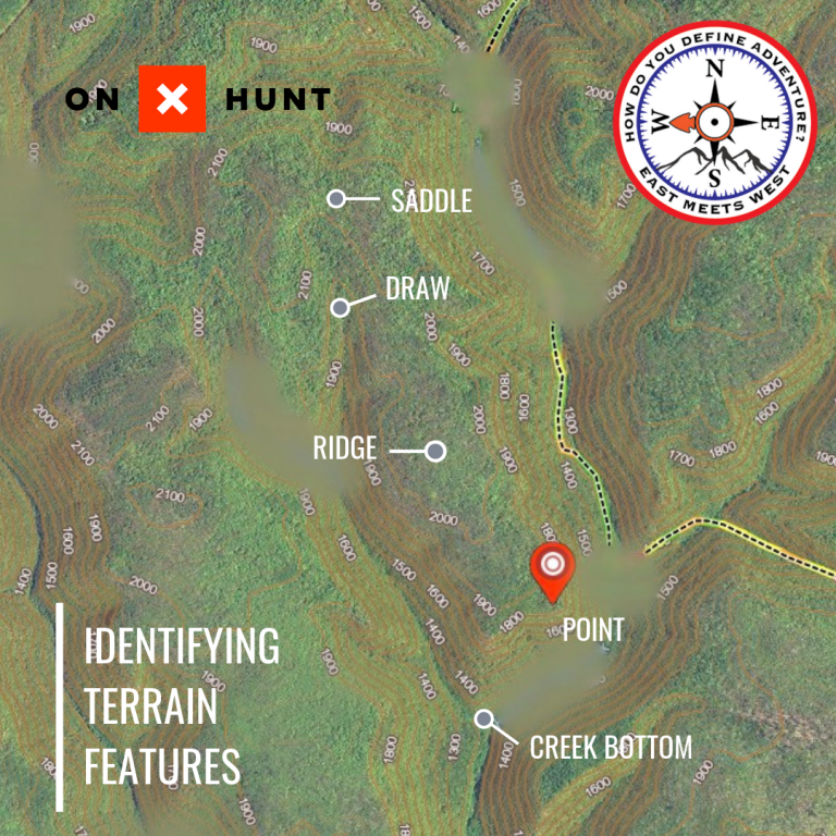
Using the OnX Hunt online app or their app for your phone, I can find overlooked public land areas or areas further away from roads that allow hunters to enjoy the big woods uninterrupted. Terrain features such as saddles, points of ridges and draws are highlighted and marked with a pin as areas to check out when scouting and/or hunting. Whether you have time to scout these areas beforehand or you are “going in blind,” by hunting the area for the first time and without scouting, you can find success if you know what to look for.
Here are the terrain features that catch my attention:
- Ridge – A ridge or ridgeline is a line of higher ground that tends to slope down on either side. Deer like to walk these ridges, with the mature bucks using less noticeable trails just over the edge of the ridge, allowing them to stay hidden.
- Point or Spur – A spur or point of a ridge is a short, sloping line of higher ground with steep drop offs on each side that normally forms a V or U-shape off of a ridge line. As the spur begins to drop off, it can create a perfect place for deer and specifically bucks to bed. The bucks bed here for a few reasons. They can see down over the hill 270 degrees, while the prevailing wind is blowing at their back. They like to have some sort of cover behind them, which can commonly be a big oak tree, downed tree, mountain laurel bush, etc. In addition, the mountain thermals allow them to be almost impossible to get close to. Wind thermals in the mountains tend to blow up the hill during the day when the sun comes out. The old, mature bucks know this and tend to spend a lot of time on the points due to the advantages of invisibility as well as wind and thermal protection.
- Saddle – A saddle is a low point between two higher points on a ridge. Saddles are used for travel from the bottom to the top of the ridge or over into the next valley. A saddle can be a great place to set up during the rut (November), since it acts like a funnel for deer travel. I like to set up on the leeward side of the saddle, meaning the side of the hill where the prevailing wind is blowing. As mentioned above, bucks like to run the ridges just over the edge rather than being on top during the daylight hours.
- Draw – A draw is a depression that slopes downward, usually with a small stream running through the middle of it. The upper end of a draw tends to be less steep, creating a travel corridor for the deer to move. Right where the steep ravine meets a more gradual terrain can be the perfect place to set up with a stand or off the ground above the trail to catch deer moving.
- Benches – A bench is known as somewhat of a flat spot on the side of a ridge and will commonly be traveled by deer rather than on the steep hillsides. If you are looking at a map, you can identify them by places where the topographic lines, usually close together to indicate steep terrain, are spread out. Benches towards the upper ⅓ of the hill are my favorite to focus on. Bucks will run these benches around the ridges to try to catch the smell of a doe in estrus during the rut; they also feel more secure here than the tops of the ridges. Focusing on hunting over scrapes on the benches can be a great tactic.
- Creek bottom – Creek bottoms that run through larger valleys can be hit or miss when it comes to hunting them. Personally, I love hunting creek bottoms during the rut, but this is only when the valley is wide enough to allow for a steady wind. Bucks will cover miles in creek bottoms looking for hot does in November or later in the season if there is a lot of snow in the mountains. If you can find a beaver pond that funnels the deer movement, you might want to mark that location.
Understanding terrain features can greatly improve your chances of having deer encounters in the mountains. I like to focus on areas at least ½ mile away from any nearby roads to limit the number of hunters that you run into. From my experience, most hunters like to stay on the tops or in the bottoms, because they’re easier to traverse. Try something a little different; although it may be tougher, it can result in a freezer full of meat and antlers on your wall.
In the next article, I will cover how I look at different types of vegetation features, how they interact with terrain features, and why the deer are in these places. For additional information on understanding the terrain features listed in this article, check out my video series where I break down the maps and show in the field examples.
If you want to use the onX Hunt app that I use for all of my scouting and hunting activities, click here and use the coupon code EMW to save 20% off of the app.


