Piecing together the history of a short-lived industry at Eagleton Fields
By Angie Jaillet-Wentling
With nearly 20,000 years of human occupation documented in Pennsylvania, there’s an amazing variety of history to highlight in our forests.
Editor’s Note: This includes Eagleton Fields Mines, located at the site of a former mining village in Clinton County in the Tangascootac watershed. Although the area contains many historical sites that need to be protected and preserved, travelers have the ability to mindfully enjoy the area via the Eagleton Mine Camp Trail, which is open to hikers, bikers and equestrians.
As an archaeologist, long-lived occupations or uses of a site or are cool, but short-lived and sometimes catastrophically ended sites provide a glimpse into the past that we rarely otherwise get. One moment in time tends to get lost over the millennia. Ephemeral sites where the landscape was used lightly or for a short period are difficult to document. Lengthy occupations or uses, on the other end of the spectrum, can make it hard to pinpoint a particular person or time. Finding a site between these extremes (i.e. a short-lived timeframe that leaves enough evidence to identify and interpret) is a gold, or in this case, coal mine.
Leaf off is the best time for a walkover if you’re looking for superficial evidence of roads, mines, railroads, foundation depressions, etc. at a site. In February, forestry staff traversed a proposed timber sale searching for the remnants of a mid-19th century mining town. A review of the State Historic Preservation Office’s database showed a mining town in the vicinity, but the location had never been field verified. To ensure that we wouldn’t adversely affect a potentially eligible (to the National Register of Historic Places) historic resource, we found ourselves in the woods on a spring-like day this winter.
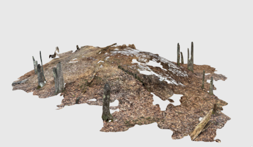
What we found were remnants of a circa 1846-1848 coal chute/ramp from the prospecting phase that likely pre-dates the town for which we searched (the photos above)!
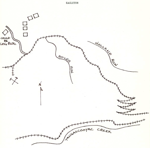
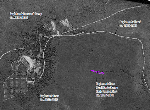
Beyond taking a few photographs and trying out a new LiDAR (Light Detection and Ranging) terrestrial scanning application (western end: https://skfb.ly/oDPyO and eastern end: https://skfb.ly/oDPyL), there wasn’t much to do on-site. Most of the delineation or mapping of the site happened on the computer using LiDAR data with a hillshade, 19th century mapping, and the 1938 aerial photograph (see below). Additional research combined with the imagery allowed for ID of other areas of the Eagleton Mining Complex to include the Eagleton Mines and Camp/Town and the Eagleton Railroad, all dating to circa 1853-1865.
At Eagleton, evidence of a short-lived industry came in the form of a funky gouge of excavated earth then used to construct a ramp that looks like a meteor strike in the imagery.
The mines and camp/town are located on private lands, but the railroad was our access into the tract. By applying an exclusionary buffer to the coal chute/ramp prohibiting mechanized equipment, we were able to avoid potential impacts to the historic resource. We were also able to specify that trees could be harvested so that they didn’t pose a threat to the integrity of the site were they to come down on their own (a “win-win” for the management of our historic resources)!

The Eagleton Fields mine operated under the Eagleton Coal and Iron Company, supervised by George Armstrong from 1853 to 1865 (Hannegan 1987; PHRS 1987). The mining camp of Eagleton purportedly included 60 dwellings, a store, office, and outbuildings. The railroad was built in 1853 to service the mine and town.
1865 wasn’t a great year for the mine and its camp. Earlier in the year, Eagleton’s coal miners (possibly 200 men) demanded increased wages and a more accurate crediting system for the tonnage mined. The strike lasted several days and was settled in part by Clinton County Sheriff John W. Smith (Hannegan 1987; PHRS 1987). Later that year, a forest fire would destroy the town and mines which never reopened at Eagleton Fields. Both were abandoned.

*Archaeological site data is kept confidential to protect sites from potential looting and destruction. What is shown is for educational and informational purposes but is meant to still be vague enough to protect it from harm. Please help us protect our history on public lands!

About the Author: Angie Jaillet-Wentling
Angie Jaillet-Wentling is DCNR’s Cultural Resources Program Coordinator tasked with overseeing the cultural and historical resources in our 2.5 million acres of state forest lands and 124 state park system. Angie is a professional historical archaeologist with specializations in landscape analysis, remote sensing and Geographic Information Systems, and historic architecture. Her research interests include public archaeology and outreach, Pennsylvania’s environmental and industrial history, and archaeology of the underrepresented. When not tramping through the woods for work, Angie can be found tramping through the woods with her family and pup for fun!


